Skip to content
Somerville Transportation Equity Partnership
  • Home
  • Green Line
  • McGrath Blvd
  • Buses
  • Health Issues
  • Transportation News
  • Background
  • About STEP
  • Toggle website search
Menu Close
  • Home
  • Green Line
  • McGrath Blvd
  • Buses
  • Health Issues
  • Transportation News
  • Background
  • About STEP
  • Toggle website search

Blog

1945 map of expanded MBTA

  • Post published:September 8, 2013
  • Post category:Green Line

1945-Boston-Subway-Expansion-med.jpg
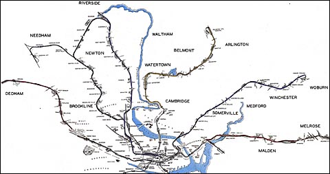
We love this 1945 vision of an expanded MBTA, with tiny drawings of each imagined station. Imagine if the envisioned line through Somerville had been built back then? View large map.

You Might Also Like

3D models of Green Line station areas

May 29, 2010

Mayor Curtatone on the Green Line

May 21, 2010

Somerville Journal: Potential Green Line impact on businesses

November 10, 2010

TRANSPORTATION PROJECTS

View a map and summaries of planned and potential projects in Somerville!

GET INVOLVED

You can make a difference! Come to a STEP meeting or join our email list to stay up to date:


FOLLOW STEP

Multiple ways to stay in touch with STEP:
Facebook Facebook
Facebook Twitter
Facebook RSS

Email us at info@somervillestep.org